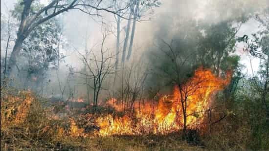
Dehradun: A forest fire that broke out near the Valley of Flowers in Uttarakhand’s Chamoli district six days ago is confined to the surface, senior forest officials said after an aerial survey on Wednesday, while a top India Meteorological Department (IMD) official has attributed the surge in such incidents to scant winter snowfall and rainfall.
The fire broke out in the forests of Painkhanda under the UNESCO World Heritage site Valley of Flowers range of the Nanda Devi National Park at an altitude of around 11,500 feet on January 9.
“An aerial survey of the fire-affected site was carried out on Wednesday. Prima facie, the fire is not very extensive and serious. It is limited to the surface and hasn’t reached the crown... due to the inaccessibility of the site, our staff is unable to douse the fire,” chief conservator of forests Sushant Patnaik said.
“We will take the report from the field and, based on the aerial survey, take further action, including whether to seek help from the Centre,” he added.
India Meteorological Department (IMD) Dehradun director C S Tomar said western disturbances, which are primarily responsible for winter rainfall and snowfall, have been near normal in frequency since December but weak in intensity.
“These systems carried limited moisture and largely followed a northward track. As a result, higher latitude regions such as Jammu and Kashmir received some snowfall and rain, while Himachal Pradesh and Uttarakhand experienced relatively weak weather activity,” Tomar said.
So far in January, the state has recorded no rainfall against a normal of 1.3 mm, while high-altitude peaks across the region remain snowless.
However, Tomar said January could bring some relief, as the month is likely to see improved rainfall and snowfall conditions.
Forest minister Subodh Uniyal has asked senior officials to look into the possible reasons behind the Chamoli fire.
In a letter to Uttarakhand’s disaster management secretary Vinod Kumar Suman, Chamoli district magistrate Gaurav Kumar said that on January 9 at 10.10 am, a report was received from personnel deployed at the Auli wireless station within the Nanda Devi Forest Division regarding smoke in the forest area near the Alaknanda River, opposite Govindghat.
“Two separate teams were sent. The first team crossed the Alaknanda River from Govindghat and headed directly to the scene. The second team was sent from Pulna village to accurately assess the extent and geographical location of the forest fire through a drone. The team that reached the scene informed that the affected area has extremely difficult geographical conditions, where steep rocks and dry grass are present, and due to heavy frost accumulation, the surface has become extremely slippery and inaccessible,” the letter said.
“The forest fire can spread to a large area due to dry weather, inaccessibility and strong winds, posing a threat to forest wealth and wildlife. Keeping this in mind, arrangements are needed for sprinkling water, if required, by monitoring it through helicopters of the Air Force or disaster management,” the letter added.
Patnaik, who is also the state nodal officer for forest fires, said that the department was fully prepared. “We have no control over the weather, but we are completely prepared to deal with forest fires,” he said.
Forest fires in Uttarakhand are typically reported between February and June, peaking in May and June.
Uttarakhand has a forest cover of 24,303.83 sq km, accounting for 45.44% of its geographical area. The presence of human habitations near forested regions increases the risk of fires. Of the total forest cover, 0.10% falls under the extremely fire-prone category, 12.92% under very highly fire-prone, 27.64% under highly fire-prone, 20.01% under moderately fire-prone and 39.33% under the less fire-prone category.
According to the Uttarakhand forest department’s official website, 38 forest fire incidents have been reported since November 1. Of these, 34 occurred in reserved forest areas, while the remaining incidents were reported in van panchayat forests. A total of 18.24 hectares has been affected, though no human or animal casualties have been reported.
December witnessed the highest number of forest fire alerts in recent years. The state received 1,153 alerts in 2025, a sharp increase compared with 386 in 2024, 773 in 2023 and 626 in 2022.
The India State of Forest Report 2023, published by the Forest Survey of India and released in December 2024, said that Uttarakhand reported 21,033 forest fires between November 2023 and June 2024 — the highest among all states — marking nearly a four-fold increase compared to the same period a year earlier.
Editorial Context & Insight
Original analysis and synthesis with multi-source verification
Methodology
This article includes original analysis and synthesis from our editorial team, cross-referenced with multiple primary sources to ensure depth, accuracy, and balanced perspective. All claims are fact-checked and verified before publication.
Editorial Team
Senior Editor
Dr. Elena Rodriguez
Specializes in India coverage
Quality Assurance
Associate Editor
Fact-checking and editorial standards compliance
