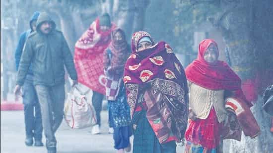
A cold wave swept the National Capital Region (NCR) on Monday as minimum temperatures dropped to a three-year low and some residents in south Delhi reported ground frost in their localities, with the India Meteorological Department (IMD) forecasting a chilly spell for another two days in the northern plains.
Safdarjung, representative of Delhi’s weather, logged a minimum temperature of 3.2°C, 4.2 degrees below normal and the lowest for Delhi in January in three years. The last time it was colder in Delhi was January 18, 2023, which logged a minimum of 2.6°C.
Ayanagar recorded a minimum of 3.2°C too. It was 3.3°C at Palam and 3°C at Lodhi Road, the lowest in the Capital.
According to IMD, a cold wave requires the minimum temperature below 10°C and a departure of 4.5°C or more below normal. It can also be declared if the actual minimum at a station is 4°C or lower.
“Cold wave conditions were realised at many stations in Delhi on Monday, with this likely to continue for another two days,” said IMD scientist Krishna Mishra.
Mahesh Palawat, vice president at private forecaster Skymet said the chill was down to two factors – consistent northwesterly winds prevailing for over a week and clear skies.
“The clear skies are allowing sunny days, but the northwesterly winds are keeping the maximum in check. At night, with no fog or clouds, the heat during the day gets lost quickly into the atmosphere. At the same time, we have decent wind speeds, so these icy cold drafts – blowing from the Himalayas – are leading to a dip in temperature,” he said.
IMD has forecast relief from Thursday due to a feeble western disturbance. Western disturbances are weather systems that bring moist air from the Mediterranean Sea, across Iran, Afghanistan, and into the Indian subcontinent. When the moist air hits the Himalayas, it is forced upward, cools down, and releases precipitation – snow in the mountains and rain in the plains below.
From Thursday, the minimum should again hover between 5 and 8°C, officials said.
Locals in some parts of south Delhi also reported ground frost.
Ashwary Tiwari, an amateur weatherman who has installed a private automatic weather station at Sainik Farms, said the minimum dropped to as low as 1.1°C in the area.
“This was due to clear skies, which led to sharp cooling at night. Towards Gurugram, parts of the Aravallis and in pockets of south Delhi, we saw ground frost too,” said Tiwari, whose car was covered in frost.
Sahil Pershad, 42, woke up to the same conditions.
“I could scrape off a thin layer off my car windows and after sunset, we could feel the chill. Our residence is surrounded by greenery, which may be making it feel much colder,” Pershad said.
Hardeep Singh Bhalla, President of the Western Avenue Resident Welfare Association (WARWA) said many people in the neighbourhood reported frosting on their cars.
“A lot of people were sharing photographs on our WhatsApp groups. Despite not being windy, it felt like it was freezing outside,” Bhalla said.
Typically, frost forms on the ground and other surfaces when the surface temperature (not just air temperature) drops below the freezing point of water (0°C) – causing water vapour in the air to turn directly into ice crystals.Clear skies and light winds, which push temperatures down, also help frost form.
Experts also said there were chances of fresh snowfall in the upper reaches of the Himalayas later this week.
“The western disturbance will start impacting the mountains from January 15 and while it will bring snowfall to the mountains, the impact over plains will be minimal. What it will do is lead to a change in wind direction to southwesterly, thus reducing the wind chill factor,” he explained.
The day was awash with bright sunshine, despite chilly winds, and recorded a high of 20.6°C, a degree above normal. It was 18.8°C on Sunday. IMD predicted the maximum to be between 19 and 21°C on Tuesday.
On Sunday, Delhi logged isolated coldwave conditions in the city. Safdarjung recorded a minimum of 4.8°C but the lowest minimum across the city was 2.9°C at Ayanagar. Palam’s low of 3°C on Sunday was also the lowest at the station in January in 13 years.
Experts say the bright sunshine and cloudless skies are catalysing a fast dip in temperature at night. “When there is fog or cloudiness, heat does not dissipate quickly. With clear skies, heat is being lost fairly quickly in these last two days, leading to such low minimum temperatures,” Palawat said.
The lowest minimum recorded at Safdarjung in the last decade in January was 1.1°C, on January 1, 2021. The all-time record is -0.6°C on January 16, 1935.
On Monday, Delhi’s air quality deteriorated marginally but was still in the higher end of the ‘poor’ category. The 24 hour average air quality index (AQI) stood at 297 (poor) at 4 pm on Monday. It was 291 (poor) at 4 pm on Sunday.
Forecasts by the Centre’s Air Quality Early Warning System (EWS) for Delhi showed a deterioration to ‘very poor’ likely on Tuesday.
“The air quality is likely to be in the ‘very poor’ category from January 13 till January 15. The outlook for the subsequent six days - from January 16 shows the air quality is likely to stay in the ‘very poor’ category,” said EWS in its daily bulletin.
The chill was palpable across the city.
Aditi Mishra, 32, a resident of north Delhi’s Civil Lines, said she has been using heaters throughout the day. “The house alone feels icy cold and it is freezing when you head out onto the balcony,” she said.
Editorial Context & Insight
Original analysis and synthesis with multi-source verification
Methodology
This article includes original analysis and synthesis from our editorial team, cross-referenced with multiple primary sources to ensure depth, accuracy, and balanced perspective. All claims are fact-checked and verified before publication.
Editorial Team
Senior Editor
Shiv Shakti Mishra
Specializes in India coverage
Quality Assurance
Copy Chief
Fact-checking and editorial standards compliance
