

Key takeaways
- 🌍 Learn more about OlmoEarth Platform: https://allenai.org/olmoearth The OlmoEarth models are our family of Earth observation foundation…
- But most organizations in the environmental space – the ones best placed to apply these models – don't have the infrastructure or…
- That experience taught us what delivering impact takes: running models cost-effectively at the right time and place, monitoring…
What happened
org/olmoearth The OlmoEarth models are our family of Earth observation foundation models, pretrained on roughly 10 terabytes of multimodal satellite data. Governments, NGOs, and other mission-driven organizations are already adapting OlmoEarth for applications including deforestation monitoring, food security, and wildfire risk. At Ai2, we know how to train and release powerful open models, and for organizations with strong engineering teams, an open model is all they need to run with.
But most organizations in the environmental space – the ones best placed to apply these models – don't have the infrastructure or engineering teams that can manage the full lifecycle: labeling data, fine-tuning models, and running large-scale inference. We’ve spent more than a decade operating platforms like Skylight and EarthRanger, software that users around the world rely on every day, so it has to work every day.
That experience taught us what delivering impact takes: running models cost-effectively at the right time and place, monitoring performance, turning raw outputs into actionable insights, and verifying those outputs drive the outcomes partners want. That’s why we built the OlmoEarth Platform: infrastructure for taking geospatial models from fine-tuning and evaluation to large-scale inference. Inference at this scale presents its own set of challenges.
Satellite imagery must be found and accessed across multiple providers, aligned across projections and resolutions, and processed efficiently. Results then have to be stitched into geographically consistent maps while the infrastructure recovers from the routine failures of distributed computing. Today, the platform can run inference across continent-scale areas in roughly a day, processing dozens of terabytes of imagery at a cost of fractions of a penny per square kilometer.
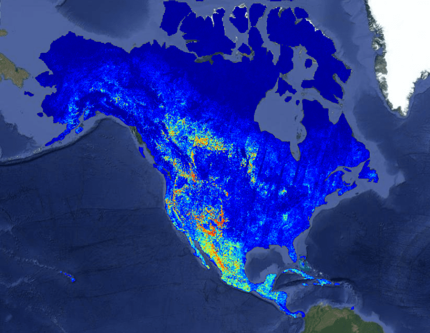
Developing it meant confronting a series of engineering challenges that others working on large-scale geospatial systems are likely to encounter as well. This post walks through those challenges and the solutions we arrived at. A recent wildfire risk map generated on the OlmoEarth Platform, with statistics.
Most ML models take in a few megabytes of data and produce a result in under a second—think LLMs processing a paragraph of text or computer vision models analyzing a photo from a smartphone. Earth observation inference operates at a very different scale—a single job fine-tuning a foundation model for maximum performance can move terabytes of data and run for hours.
The inputs may span multiple spectral bands, sensor types, and time steps across a large geographic area. They can come from several providers, each using different projections and resolutions, and may include observations that are missing or obscured by clouds. The output is itself a map, so every prediction must remain precisely aligned with the same projection and coordinate grid as the areas around it.
Even acquiring the data can be a major challenge. Prediction jobs often spend more time downloading and preparing imagery than running the model itself, making efficient data pipelines critical. Those pipelines must handle high-volume I/O while providing the compute needed to reproject and resample imagery.
Because data acquisition and preparation often dominate an inference job’s runtime, assigning that work to GPUs would leave the system’s most expensive hardware doing tasks better suited to CPUs. We therefore divide each job into three stages, each matched to a distinct hardware profile: The OlmoEarth Platform distributes these stages across many machines while keeping GPUs fully utilized.
Multiprocess data loaders continuously feed each GPU, while completed outputs stream directly to blob storage. OlmoEarth Run, the platform’s execution layer for large-scale inference jobs, divides the geographic region covered by each job into partitions sized for individual compute instances (workers), then subdivides those partitions into smaller windows that the OlmoEarth models process.
Because the partitions are independent, the same stage can run across thousands of compute instances at once. We recently used this approach to generate a wildfire-risk map covering all of North America. At peak, the run used roughly 19,600 CPUs and 994 GPUs in parallel, with network throughput exceeding 168 GB/s. 5 hours of wall-clock time—a 155× speedup. Fan-out is not unbounded, though.
Why it matters
Because each window can be handled independently in a separate forward pass, work on one part of the map does not need to wait for another. In practice, a state-sized area might become a hundred or so partitions, while a continent-scale run can become thousands. Adjacent partitions overlap slightly, and we reconcile that overlap when the outputs are assembled so no seam appears in the final raster.
What to watch
More workers push against cloud quotas, so parallelism is a per-run knob, one of several that we can adjust on individual jobs. Output resolution trades data volume and compute for detail; model size trades GPU time for accuracy; caching raw imagery trades storage for speed across repeated runs over the same area. The right setting depends on the task – and budget – at hand.
Given a geographic region and time range, the platform first has to determine which satellite scenes should feed the model.